

Seeing Guanacaste from above isn’t only possible from a plane or a helicopter. Cerro Caballito (Caballito Hill) in Nicoya gives us a 360-degree view of a good part of the province, from Orosí volcano in the border canton of La Cruz to the Gulf of Nicoya and its islands.
Our goal is to see the sun set. We leave at 2:30 p.m. from the community of Caballito, 37 meters (about 120 feet) above sea level, between the towns of Quebrada Honda and Corralillo. Our destination is the top of the hill, at 440 meters (about 1440 feet) above sea level.
We leave the car at the home of our guide, Victor “Carrillo” Obando.
He, his brothers and sisters inherited a treasure that we were about to journey through: 113 hectares (280 acres) that are almost as diverse as the province itself. Pastures, primary and secondary forests, a cavern, springs of water, rocky terrain, fruit trees and wild animals.
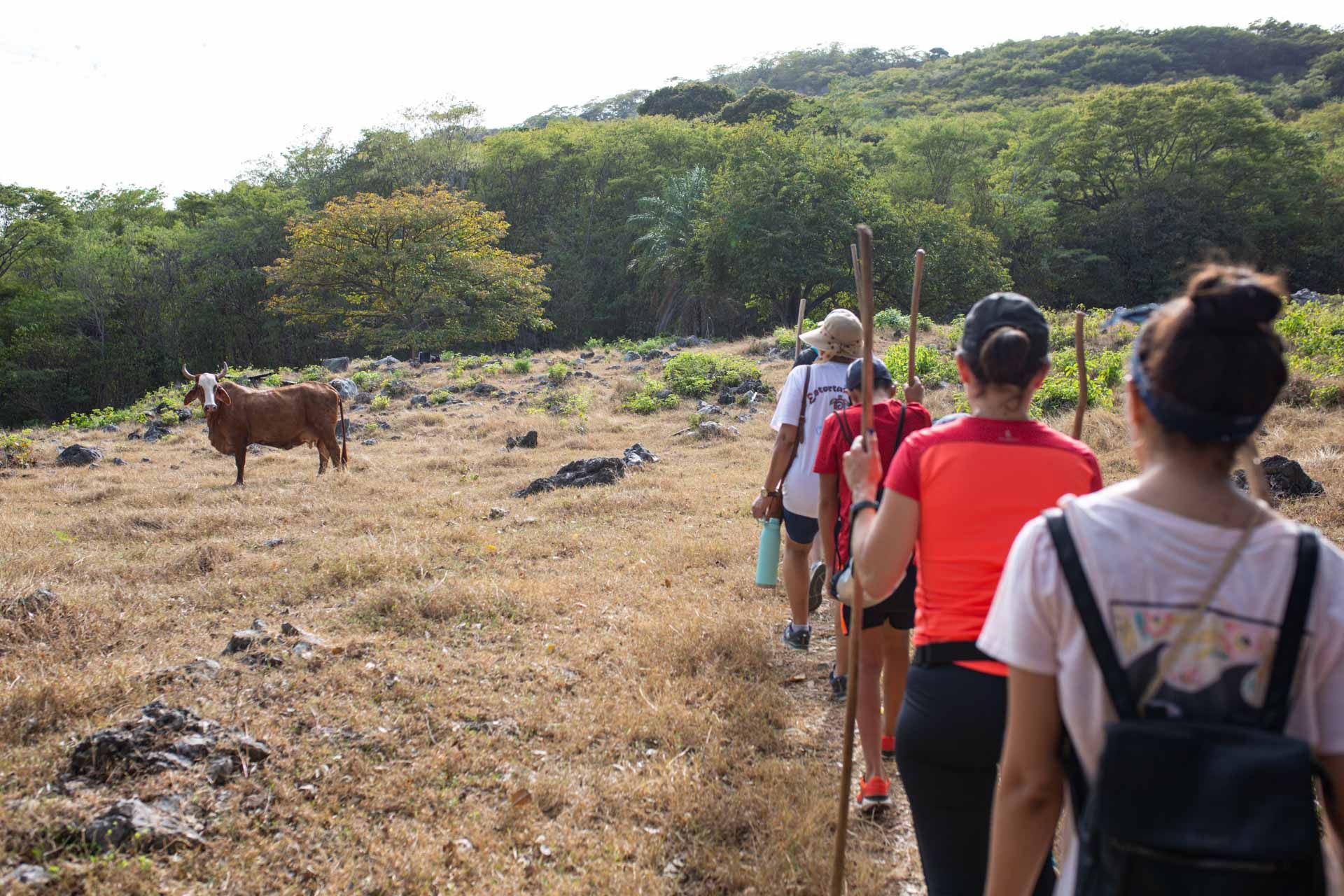
The path begins through a pasture with cattle that belong to one of Victor’s sisters. Photo: César Arroyo Castro
Victor was born and raised here, and 10 years ago, he began to guide neighbors from the community to the top of the hill.
“There were two, three, five people who came a year,” Victor recalls. That changed in October of 2020, when he replaced his old Nokia phone— which only allowed him to send text messages and make phone calls— with one that allowed him to have WhatsApp, Messenger and Facebook for the first time.
With the new cell phone, his sons and daughters helped him create a Facebook page and since then, “this has picked up,” he says. That’s how we got the urge to climb it ourselves. On social networks, people who live in the Nicoya area especially began to share photos of the place.
Now even his wife, Liseth Obando, has gotten involved in the venture. She arranges the tourist schedule, takes calls on her home phone and can even prepare breakfasts and lunches for people who climb the hill, as long as they request it when they book their tour.
I feel very happy and grateful to God,” Victor tells us. “The goal that I had is being fulfilled. I love the mountain and my son helps me unconditionally. He never tells me, ‘Daddy, I don’t want to.’ He is always at my side,” he remarks as he looks over the path we are walking on and the path lying before us.
Odes to Guanacaste
We go across a pasture field with cattle and a rocky slope to get to the mountain. Then 300 meters (about 1000 feet) into our trip, we reach the El Voladero viewpoint. From there, we can already see Guanacaste’s majestic volcanic mountain range at the far end of the landscape: Orosí, Rincón de la Vieja, Miravalles and Tenorio volcanoes.
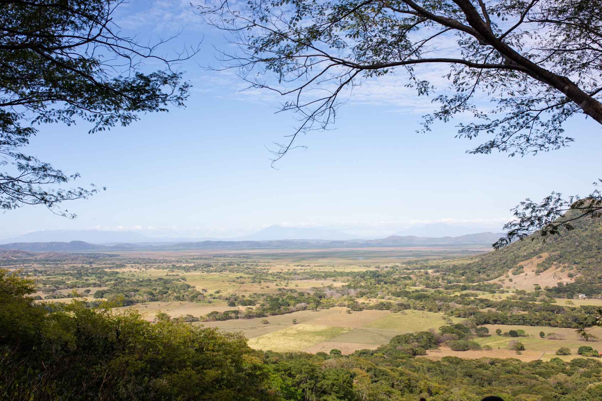
From the first viewpoint, you can see a good part of the province. Photo: César Arroyo Castro
At their feet lie the cities of Liberia, Cañas, the wind farms of Tilarán and even the structure of La Amistad bridge over the Tempisque River. From here, this is already a celebration of Guanacaste: its infinite green tones and formations seem to radiate before our eyes.
After the first viewpoint, the temperature begins to drop. The reforested woods lower the thermal sensation even though Nicoya’s heat still beats down on us at 3 p.m. Since the moment we left, Victor has already had to answer dozens of calls from visitors from all over the country who want to schedule his tour.
“I tell them to send me a WhatsApp message and that I’ll look at it when I get back from the mountain,” he tells us. By the end of the afternoon, sure enough, his phone will have a large number of messages that his wife, Liseth, will organize.
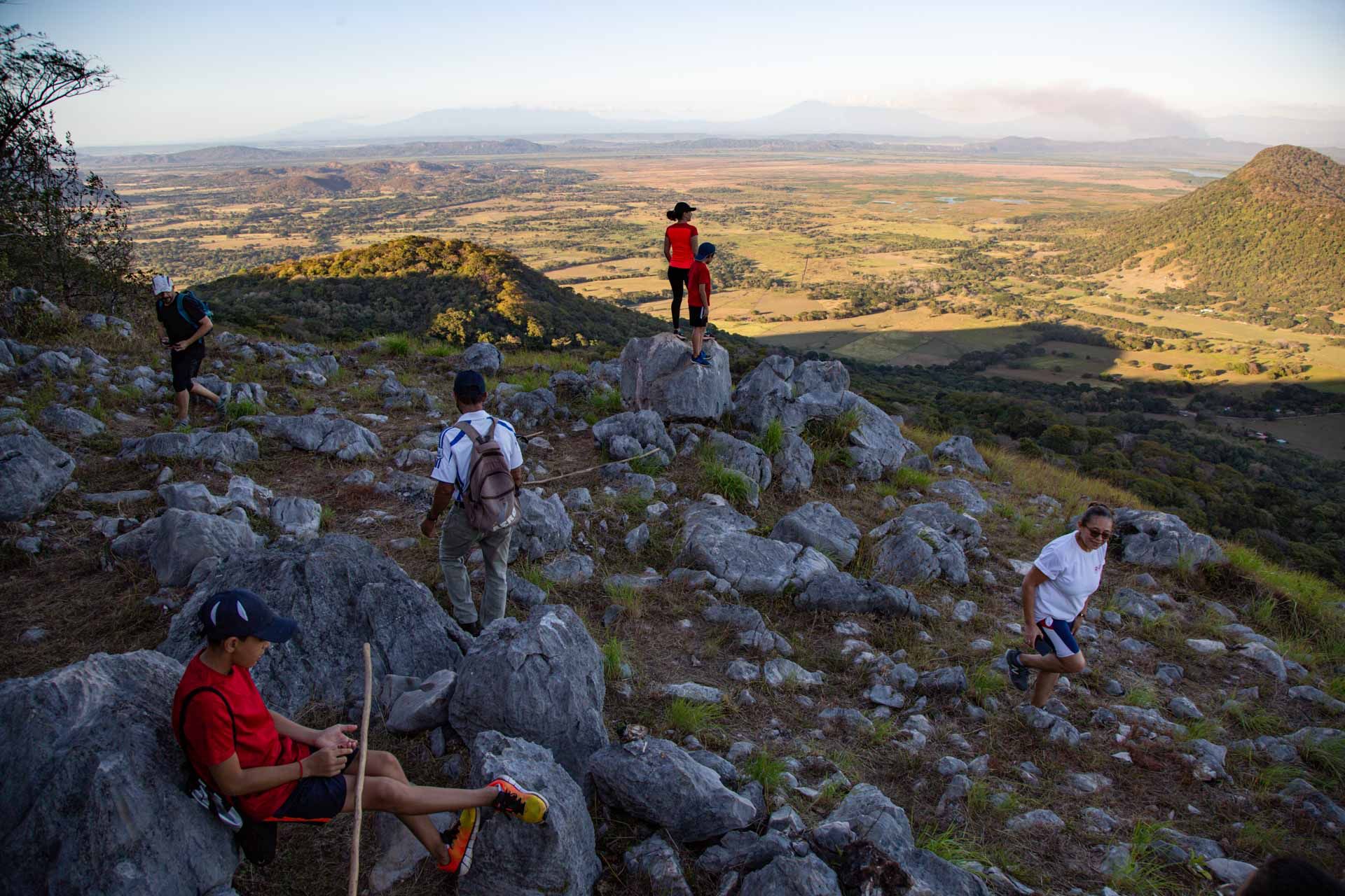
A group of six people of different ages are going up with us, from Victor himself, who is 60 years old, to 11-year-old kids, who live in Nicoya and Heredia.
According to Victor, the tour is suitable for people seven years old and up. He and his son— the guides— evaluate the abilities of each group to set the rhythm of the tour, which has benches and places to rest along the 3-kilometer (about 1.9-mile) route.

The three-kilometer uphill hike took us two hours. Going back down, with some flashlights that Victor brings with him, took just over an hour. Photo: César Arroyo Castro
Two more viewpoints await us: La Talqueza and La Penca. But in between, we enjoy the reforested woodlands, which was Victor’s grandfather’s pasture before the 90’s.
We also go by an archeological zone and a water spring that Victor says indigenous groups lived near. The site still preserves the presence of those ancestors. He remembers that when he was a child, he heard the echoes of their unrecognizable voices himself and now that he’s older, he has heard the sounds of axes cutting down trees.
The field that comes after the archeological zone is full of bananas and fruit trees such as orange, goldenberries, mango, cas, jocote, tamarind, sapote and even coyol. Victor and his son have also grown vegetables like ginger and turmeric. They’ve done so because they see thousands of more opportunities in this land to conserve and enjoy nature.
“All my life, I’ve lived in the field and I love it,” he tells us as we walk through the harvest fields. “I love animals and nature,” he emphasizes.
Right after that, we arrive at El Matapalo cavern. The characteristics of the land around Cerro Caballito bear many similarities to Barra Honda National Park, which we’ll see later at the end of our journey.
The cavern isn’t a regular stop on the tour. It’s only included if visitors mention that they want to see it prior to going up. Victor shows it to us. It’s small, barely 30 meters (about 100 feet) deep.
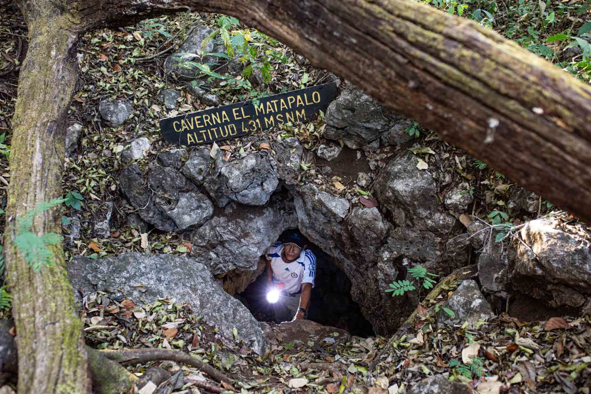
The Matapalo cavern is the only one that Victor has found within the piece of land. Photo: César Arroyo Castro
After the cavern, when we stomp and hit the ground with our hiking sticks, we hear the hollow ground. According to Victor, geologists from the country’s universities have told him that there may be underground tunnels.
As we continue walking, he tells us why it’s called Cerro Caballito. Many years ago, people from the community of Pozo de Agua went up to cut down trees on the mountain to plant wheat, corn and beans. One day, they found a mare with a small, sturdy horse. They took him to Pozo de Agua three times to tame him, but all three times, he would be on the hill again by dawn. “What happened to the horse afterward? Nobody knows,” Victor tells us.
After a few minutes, we reach the next viewpoints. The cattle we passed right alongside earlier now look tiny, barely recognizable. Our view is still 180 degrees, but the extra distance reconfirms that from above, Guanacaste is as infinite as it is beautiful.
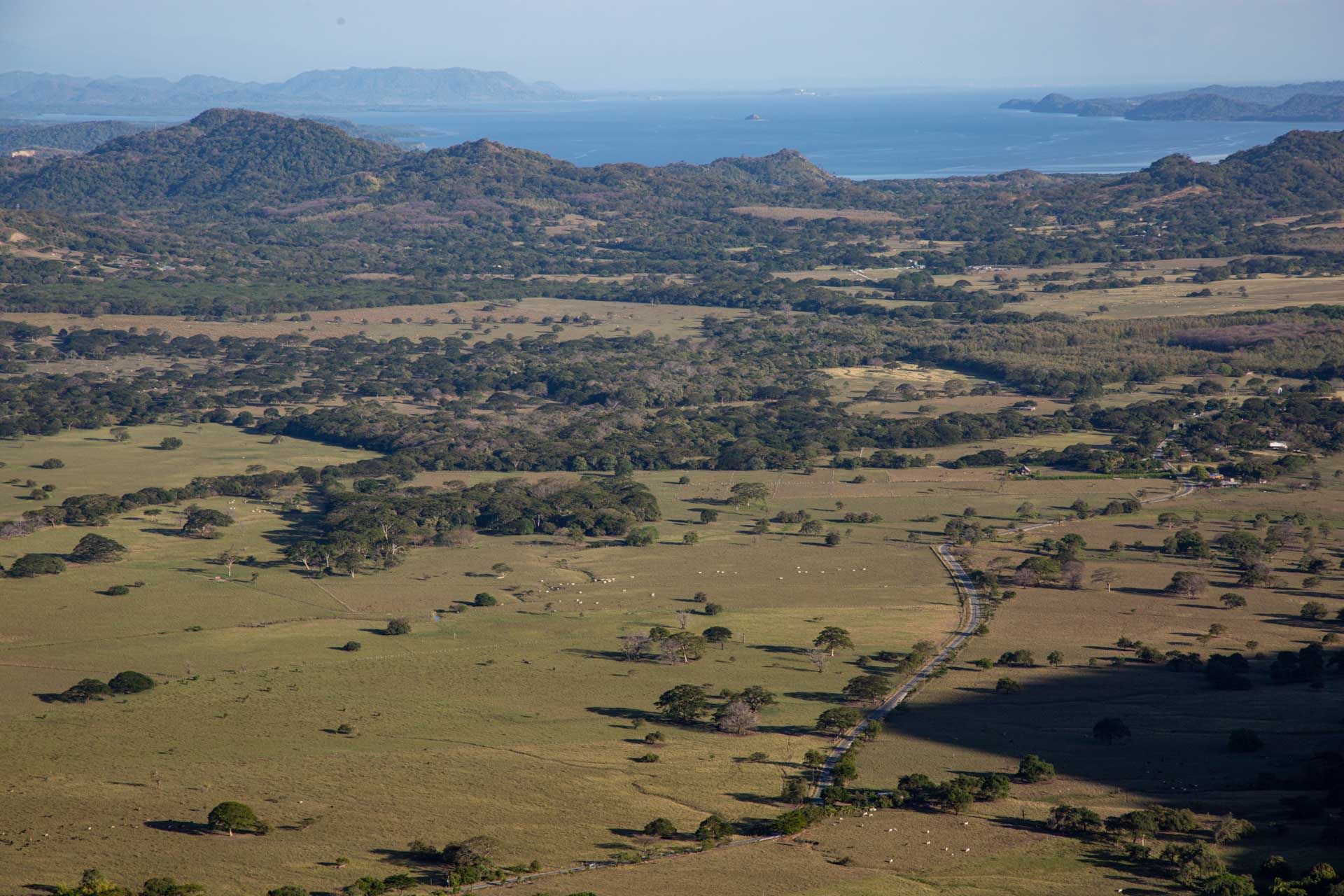
The Gulf of Nicoya
viewed on the ascent to the top of Cerro Caballito. Photo: César Arroyo Castro
Here, in addition, we find the stone with the hole, famous because dozens of visitors are sure to stop to take pictures. The stone is possibly one of the main wonders.
The Last Breath
The last climb before the 360-degree lookout is rocky. Without a doubt, it is our main physical test: the steepest ascent and it has obstacles. It confirmed why Victor considered it necessary to give us hiking sticks and even pay for accident insurance for visitors.
After taking a few deep breaths, we reach the top. Even here at the top of the hill, Victor and his son have placed benches and platforms for visitors to rest. This Nicoyan’s dream is to continue promoting visits to and conservation of this wonder called Cerro Caballito.
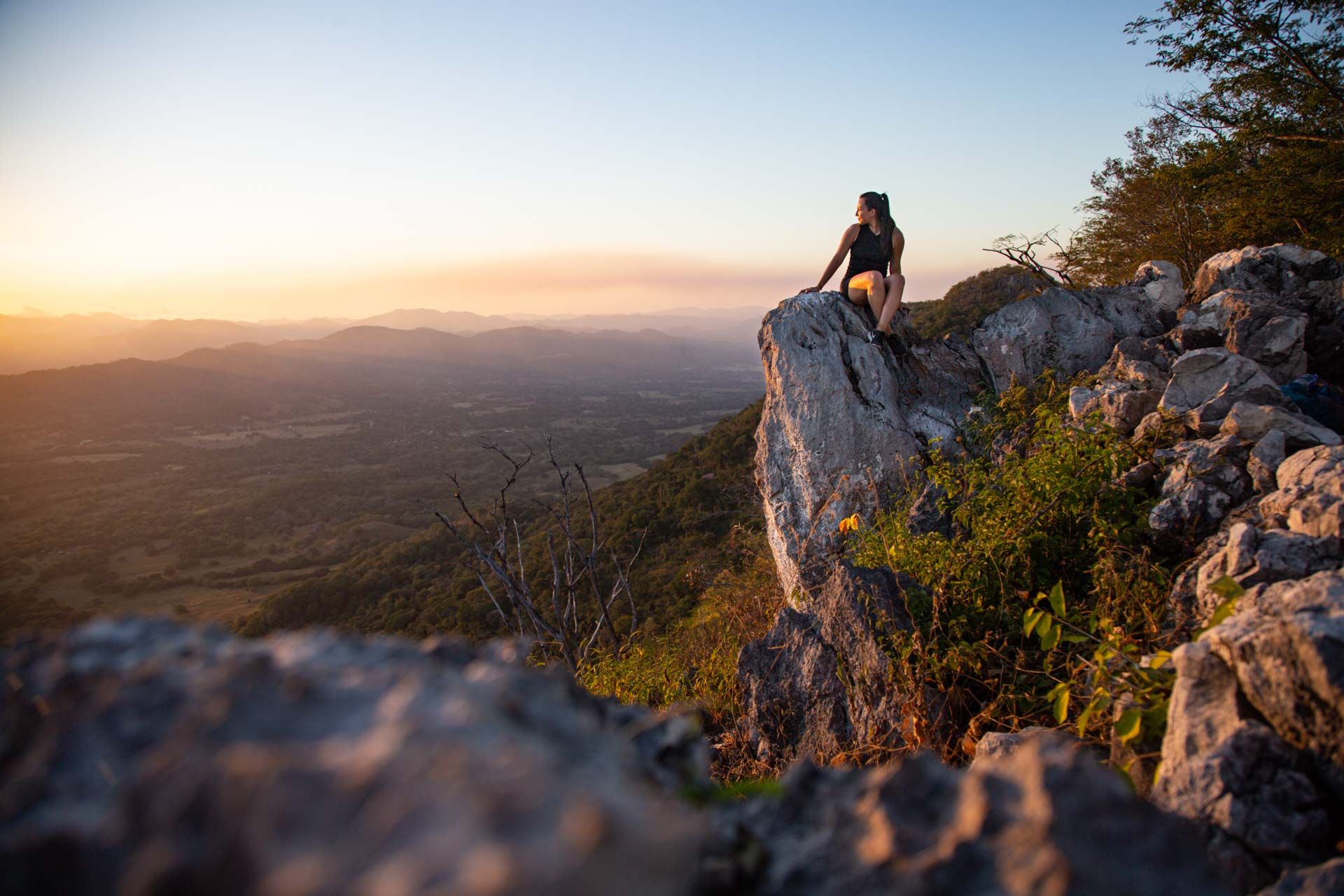
At the top, we are captivated by the immensity of the province and the colors of the sunset that dye it. Guanacaste is at our feet and its grandeur is so immense that even here, it makes us feel tiny.
After 5 p.m., we saw the sun go down behind the mountains of Barra Honda National Park. Victor “Carrillo” Obando guided us through the three kilometers from Caballito to the summit. Photo: César Arroyo Castro
Overview
- WhatsApp Víctor Obando: 86542332
- Difficulty: Medium-hard.
- Not accessible for people with reduced mobility.
- Suitable for people seven years old and up in optimal physical condition.
- Parking: Yes.
- Pets: No.
- Camping area: Yes.
- Time: Varies according to the group, but an estimated two hours going up and just over an hour going down.
- What to bring
- A light backpack with water and snacks (bar, fruit, candies).
- Comfortable shoes.

Comments